Places editor
The Places editor is an editor dedicated to adding or modifying places, by standardizing their name thanks to a database of places available on the Internet.
The Place editor is only accessible from a place. It is not accessible from the menu bar.
Description
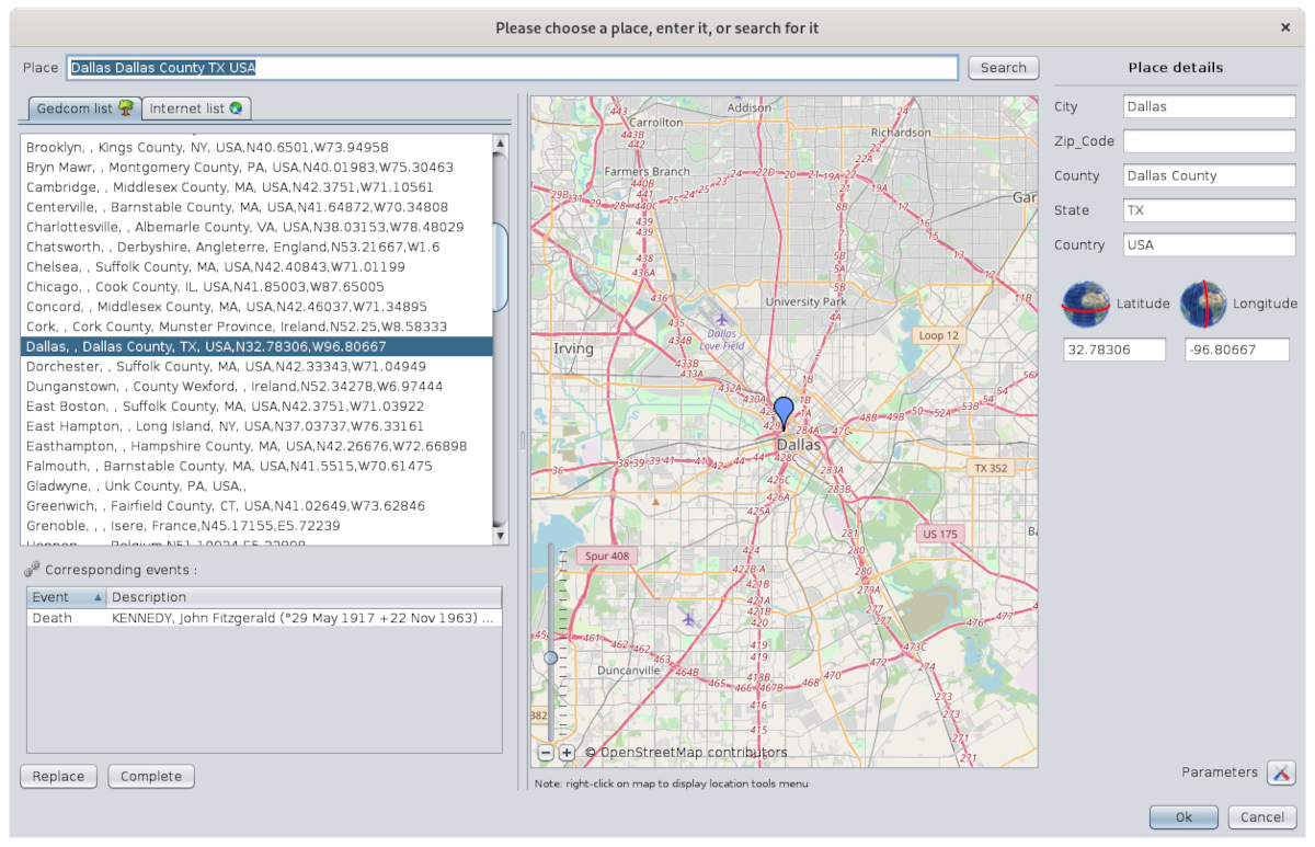
The window includes:
- a title that is important
- the name of the place to be modified or searched
- two lists of places matching the search place
- the list of all events that use this place in the genealogy
- buttons to retrieve details of a found place
- a positionning map
- details of the place
- a Parameters button
- the OK and Cancel buttons to confirm your modification
Window title
There are two possible titles for this window depending on whether you are editing the location of a single event or several at at the same time.
- One: it is the modification of the place of a particular event for a particular entity in the genealogy.
- Several at a time: it is the modification of the place for all the events that use it in the genealogy. All the events that use this place are therefore modified at the same time.
In the case of the modification of a single place, you launched the Place Editor from one of the editors, Cygnus, Aries or Gedcom, and the title bar should say this:

In the case of editing the place of several events at the same time, you launched the Place Editor from the List of Places view or from the Table of Places view, and the title bar should say "Editing all places like" and specify the name of the place.
For example, here is what the window title says if you edit the place Dallas from the List of Places view of the Kennedy genealogy:

Before validating the modification of a place, look at this title to be sure of the context you are in.
Place to modify or search

The Place field displays the place currently being modified or lets you enter a place to search.
Lists of places found
The places found correspond to all the places "similar" to the criteria entered in the Place field.
On the left side of the window are two lists of found places, depending on whether they were found in the current genealogy Gedcom or on the Internet.
Gedcom list Tab
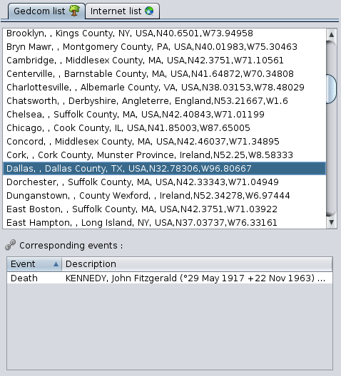
This tab has itself two lists that work together:
- At the top, the list of places found in the Gedcom file of the currently open genealogy
- At the bottom, the list of genealogy events corresponding to the location selected in the Gedcom list.
The event list has two columns:
- The Event column indicates the type of event (birth, baptism, marriage, occupation, etc.).
- The Description column shows the name and ID number of the individual involved in the event; if it is a family, the column shows the name and ID number of each member of the corresponding family.
Clicking on the column headers does an alphanumeric sort of the rows.
Internet list Tab
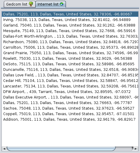
This tab lists the main places found on the Internet - Geonames - for the last search performed. This list is empty when the window is opened.
Buttons for retrieving details of a location
These buttons are used to retrieve all or part of the details of a selected place from the list of found places.
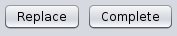
Replace Button
It replaces all the details of the place to be modified by those of the newly found place.
Complete Button
It only adds the missing details of the place to be completed with those of the newly found place.
Positioning map
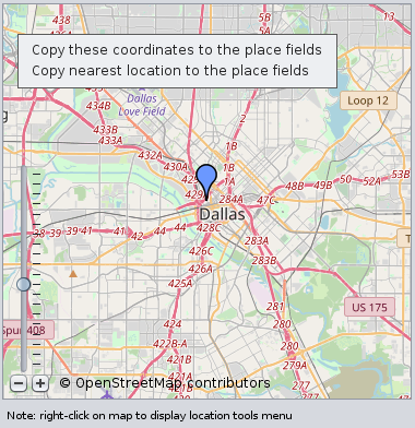
The central area of the place editor displays a map to position either the place being edited or the place selected in either of the two lists of places found.
A scale, at the bottom left, allows you to adjust the zoom.
This map offers a context menu that opens with a right click on any point of the map. This specific context menu lets you determine the coordinates of the point clicked. It contains the following actions:
- Copy these coordinates to the place fields: copies the geographical coordinates of the clicked point on the map to the Latitude and Longitude fields of the Place details.
- Copy nearest location to the place fields: copies the geographical coordinates of the nearest place of the clicked point on the map to the Latitude and Longitude fields of the Place Detail.
Detail of the place
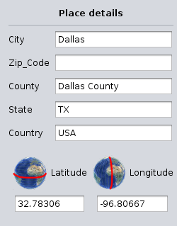
The details of the place are in the right-hand panel. It includes the place jurisdiction fields - defined in the currently open genealogy- and the place Geographic coordinates fields.
The list of fields displayed may therefore differ from one Gedcom file to another.
The definition of the jurisdictions is done via Menu/File/Properties.
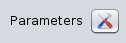
Parameters Button
It opens the following window, which matches the names of the jurisdictions used by Geonames with the current open Gedcom file. Follow the instructions that are displayed in the window and press OK.
OK button
Validates the modifications made to the place and closes the places editor.
If the Places editor was editing all the instances of the same place, all of them will be modified.
Cancel button
Cancel the modifications and closes the places editor.
Usage
The purpose of the Place Editor is to provide you with place names from around the world in a standardized format that matches the structure of your places in your genealogy.
You may need this editor in several situations:
- Creating a place: you have an event that took place in a place that you had not yet entered.
- Using an already entered place: you have an event that took place in a place you have already entered, and you want to enter it exactly as it was spelt, to avoid ending up with duplicate places.
- Modification of a place already entered: you have entered a place and you want to make a correction to it, but it is used in many places in your genealogy and you want to correct all of them in one go.
In all cases, the principle of use is the same:
- Search the place in your Gedcom or on the Internet
- Verify the place information: on the map and in the corresponding events in the Gedcom list tab
- Update the place details
- Validate
Please note that places can only be deleted from the Gedcom Editor.
Search the place in your Gedcom or on the Internet
The search is based on the text entered for the place in the Place field.
The search in your genealogy is immediate upon entering this text and the result is displayed in the in the Gedcom list tab.
The search on the Internet is done in the free Geonames database of all places around the world once you click on the Search button.
During the Internet search, the button is greyed out. Once the search is finished, the button is accessible again and the result is displayed below in the Internet list tab.
If no place matches your search, or if the results do not match at all, you can change the search field and launch another search.
Verify the place information
The search results are in the two list tabs: internal to your Gedcom file, and external on the Internet.
Positioning
The selection of one of the place item in either of these lists immediately positions the place on the map so you can see where the place is located.
Please note this only works for places with geographic coordinates, which might not be the case for all places of your Gedcom file. To fill them in, if this is not the case, you have to edit the place from the List of Places or the Table of Places, because the editing will be done for all events that use this place at the same time.
Related events
If it is a place already present in your genealogy, the list of corresponding events is displayed, allowing you to evaluate the impact of your modification, depending on whether you are modifying a single event or several.
Double-clicking on an event line displays the entity in the other views of Ancestris. This allows you to have all the details about this event.
Update place details
Replace or Complete place details from the place found
Once you have found the right place, you can retrieve all the details of the place in your genealogy with the Replace button, or only the parts you are missing with the Complete button.
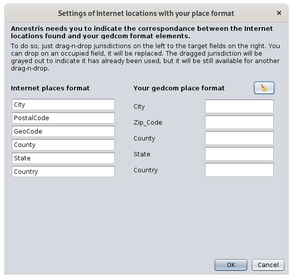
If the place is retrieved from the Internet and this is the first time you are retrieving one for your genealogy, Ancestris will need to know the correspondence with your place structure.
Indeed, places on the Internet generally have a different structure than yours, and Ancestris wants to be able to copy the right jurisdictions into the right fields.
At this point, Ancestris offers you the Parameters window. All you have to do is drag and drop jurisdictions from the left into the right boxes and save. Ancestris will remember this for future times.
For example, here is a correspondence after having assigned 5 of the Internet fields and having left out the field PostalCode.
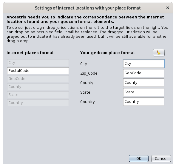
As soon as you click OK, the items you wanted are copied into the Place detail.
Retrieving geographic coordinates from the map
It is possible to enter geographic coordinates using the map instead of entering them by hand.
To do this, right click on the map at the exact point or approximate (surrounding area) places you want to use. The context menu with both actions appears.
The geographical coordinates are then copied in the detail of the place.
Changing details
To do the final touch to your place details, it is also possible to modify the elements that interest you directly by hand.
These fields can be modified and an auto-fill mechanism makes it easy to enter already known jurisdictions.
It works like this: if a low-level jurisdiction is changed, the higher-level jurisdictions are immediately changed as soon as you type, based on known genealogical locations. If there is no match, the higher-level jurisdictions are reset to their pre-entry value.
Validate
If you are sure of your change and you checked the window title to see if you were editing a single event or several, press OK. The window closes and you are back to where you were when the window opened.
If in doubt, it's best to cancel your manipulation and start again.
If you make a mistake, you can always undo it with the Undo button on the Ancestris toolbar.
The <Escape> key closes the window without validating.
Customization
Three elements can be customized in this window.
Jurisdictions
The jurisdictions listed in the location details only reflect those defined in the properties of the Gedcom file.
Before any modification of the location, it is preferable to check that they are the ones you want.
Refer to the corresponding section to modify the properties of the file, accessible from the Menu bar, then File, then Properties.
Window size
This window is rich in information and its size is memorized. You can therefore enlarge it to the maximum to get a good view of the lists and the map.
Divider bar
It is possible to adjust the respective size of the map and the lists by moving the vertical separation bar between the two.
Its position is memorized from one time to the next.