List of places (SL)
The List of Places allows you to edit all the places in a genealogy, geolocalize them, merge them, and verify that they have been entered correctly and organized in a consistent manner.
All the places found in the genealogy are listed, with their geographical coordinates.
For each of them, it is possible to see the events that occurred there.
The sorting of the list can be modified, as well as the display format.
It is also possible to merge places that should be identical, and to define or correct the geographical coordinates of those that are wrongly positioned.
Description
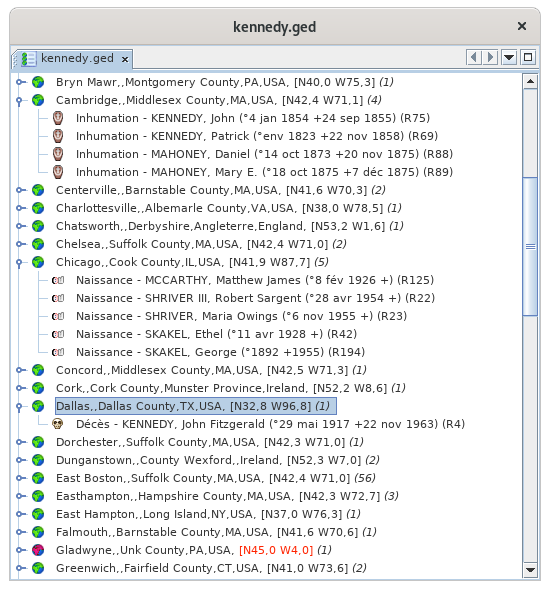
The List of Places is a two-level tree list:
- Places
- The events that occurred there
The event level can be unfolded or folded by clicking on the flap :
Places
Each place line displays the following characteristics:
- An icon whose color indicates if it could be located by Ancestris
- His name
- In square brackets, its geographical coordinates
- In brackets, the number of events that occurred there
The different lines of places are classified in alphabetical order.
Green place icons
A green place icon ![]() indicates a place that seems to be suitable. In this case, the coordinates can be displayed in blue or black.
indicates a place that seems to be suitable. In this case, the coordinates can be displayed in blue or black.
- Coordinates displayed in blue (example: [N40,0 W75,3]) means that Ancestris found the coordinates of this place on the Internet.
- Coordinates displayed in black (example: [N53,2 W1,6]) mean that Ancestris found the coordinates of this place in the Gedcom file, and it is probably you who put them there.
However, it can happen that some places are badly positioned, despite the presence of the green icon. To remedy this, see paragraph below A "green" location is incorrectly positioned.
Red place icons
A red place icon ![]() indicates a place whose coordinates Ancestris did not find.
indicates a place whose coordinates Ancestris did not find.
In this case, the coordinates are always displayed in red (example: [N45,0 W4,0]).
To remedy this, see the paragraph below: Intervention on red locations
Events
Each event line displays its characteristics :
- The type of event in the form of its symbol (birth, wedding, profession, etc.)
- The type of event in any letter
- The name of the individual involved in the event, followed by his or her ID number in brackets (Ixxxxx). If the event concerns a family (marriage, contract, divorce...), the line displays the name and ID number of each of the two members of this family, as well as the ID number of this family (Fxxxxx).
The different event lines are sorted alphabetically by the name of the event and the name of the individual.
The List of Locations covers several needs, which are as follows, from the most frequent to the least frequent :
- Search for a place in the list, directly by typing on the keyboard the place to be searched.
- Acting on locations to modify them, from a right click on a place in the list.
- Act on an event of a place, from a right click on an event in the location.
- Search for the coordinates of all locations. This is done at the first launch of the list of places for a genealogy, and then from the geographical view.
Search for a place in the list
The search for a location is done by first selecting an item from the list and then typing the first letters of the jurisdiction you are looking for.
- A search window opens at the bottom left of the list.
- The selected location line moves in the list on the first occurrence of the entered string.
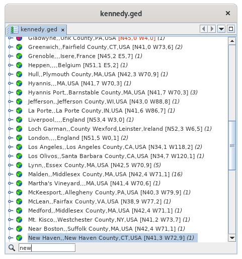
You see above the first letters of "New York" that were entered, the search field appeared in the lower left corner, and the New Haven location line was highlighted.
In order for the search field to appear, any location line must first be selected.
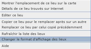
The Place List allows the use of a context menu, available by right-clicking on a place line.
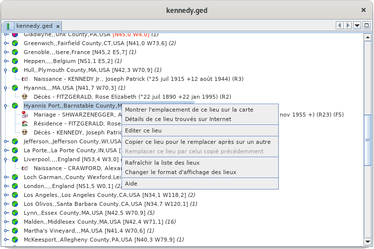
The following describes each of the actions in this context menu.
Show the location of this place on the map
This action activates the Map View and shows the location of the place on the map:
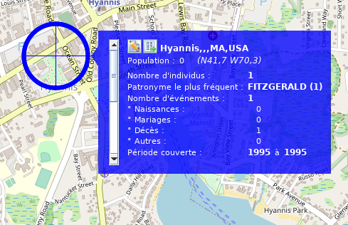
The same result would have been obtained by double-clicking directly on the Hyannis Port location in the list.
For more details on its use of the map, see the page dedicated to the Geographic Map.
Detail on this place searched on the Internet
This action displays various information that can be used to complete or correct the data entered from the editor:

C'est en particulier l'un des moyens pour identifier les codes INSEE des communes.
Edit this place
This action allows you to edit the location.
It is generally through there that you will pass to "repair" your premises, i.e.
- Repositioning places that are poorly or not accurately enough placed,
- find the ones that were not found (the places with red icon).
Clicking on this action opens the next window for editing a location.
Note that when this editor is called from the list of places, it allows you to edit all places with the same name and coordinates.
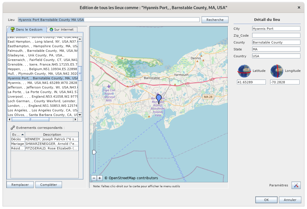
For more details on how to use it, see the Place Editor page.
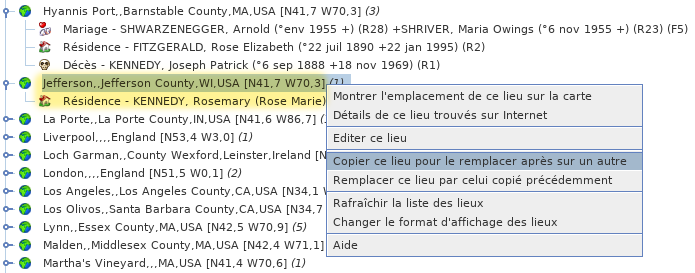
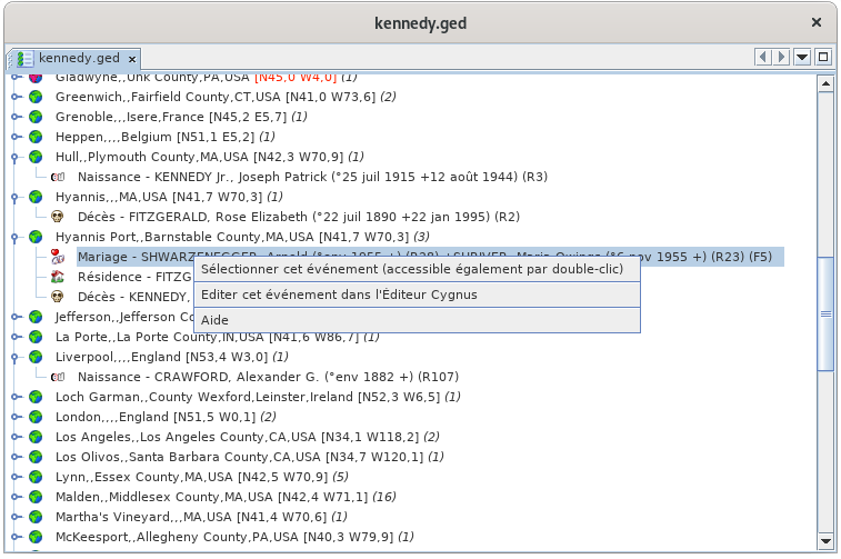
Copy this place to replace it afterwards on another one
The interest of this action is to merge two places.
The action allows you to copy the full name with its coordinates of a first selected location to the clipboard, which will then allow you to paste it on another location using the command below.
The first place is the one you wish to keep. Copy the first one into the second one to overwrite it with the first one.
For example, I copy here the Jefferson place, which contains the event residence of Rosemary Kennedy:
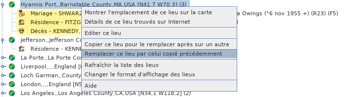
Replace this place by the one previously copied
This command is the counterpart of the previous one to merge two places.
The place from which this second action is performed will be deleted.
At the time of this action, this place disappears from the list and the events that were attached to it are placed under the first place next to the events that were already there.
In the following example, if I replace the place Hyannis Port with what I have just copied:
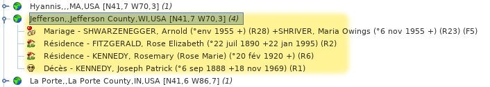
I then find the following list of places, where Hyannis Port disappeared, and Jefferson contains 4 events resulting from the merging of the two places:
Refresh the list of places
This action forces the reclassification of the list and associated events.
In principle, modifying a location updates the list immediately, but it may be necessary to force this refresh.
Changing the display format of locations
This action allows you to customize the way the places are displayed in the list and therefore to sort them differently.
Refer to the Customization paragraph below.
After unfolding the list of events of a location, you right-click on an event and the event story menu below appears.
The following describes the actions in this menu.
Select this event
This action, also accessible by double-clicking, allows you to select the individual in all Ancestris views.
Edit this event in the Default Editor
This action opens the default editor, here it is Cygnus on the example, in order to make changes in the entity (individual or family) associated with the selected event.
You can change the default editor in the Preferences. The name in the context menu of the event will then have changed.
Search for coordinates of all locations
CommentHow does Ancestris trouve-t-ilfind lesgeographic coordonnées géographiques ?coordinates?
AuWhen lancementlaunching dethe laPlace vueList Listeview desand lieuxthe etMap de la vue Carte géographique,view, Ancestris vérifiechecks lathe présencepresence desof coordonnéesthe géographiquesgeographical descoordinates lieuxof dansthe laplaces généalogiein concernée.the genealogy concerned.
SiIf plusmore dethan lahalf moitiéof desthe lieuxplaces n'ontdo pasnot dehave coordonnées,coordinates, Ancestris vousoffers proposeto deretrieve lesthem récupérerfrom surthe Internet :Internet:
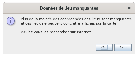
SiIf vousyou êtes d'accord,agree, Ancestris vawill récupérerretrieve lesthe coordonnéesgeographic géographiquescoordinates deof l'ensembleall desthe lieuxplaces dein votreyour généalogiegenealogy suron lathe basefree géographiquegeographic libredatabase https://www.geonames.org/.
CetteThis recherchesearch peutcan égalementalso êtrebe déclenchéetriggered àfrom partirthe deGeographic laMap Carteusing géographiquethe par"Search lefor boutonlocation coordinates" button 
"Recherche desin coordonnéesthe des lieux" dans la barre d'Outils.toolbar.
EnDepending fonctionon duthe nombrenumber deof lieux,places, cecithis peutmay prendretake quelquesa few minutes. LaThe progressionprogress deof lathe récupérationcoordinates desretrieval coordonnéesis estindicated signaléeby para uneprogress barrebar d'avancementin dansthe la barre d'état d'Ancestris enstatus basbar àat droite.the Celle-cibottom seright. développeThis lorsqu'onbar cliquegrows dessuswhen etyou click on peutit arrêterand leyou processus.can /!\stop Bugthe :process. nombre de lieux anormal et processus qui n'est plus interruptible.
EnIn cascase deof problèmeconnection deproblem connexionor ouunavailability d'indisponibilité deof geonames, vousyou avezhave cethis messagealert d'alerte : message: "ErreurError desearching rechercheon surthe internet. UtilisationUse desof informationsthe desinformation lieuxof conservéesthe enplaces localkept locally".
DansIn lethe casgeneral général,case, lesthe coordonnéesblue bleuescoordinates [N40,0 W75,3] sontare temporairementtemporarily stockéesstored dansin una fichierparameter paramètrefile duin Répertoirethe utilisateurUser surDirectory votreon ordinateuryour etcomputer nonand pasnot dansin lethe fichierGedcom Gedcom.file. LaThe raisonreason estis qu'Ancestris ne fait que proposer, c'est à vous de choisir les coordonnées à enregistrer dans le fichier Gedcom. La contrepartie en est que si vous effacez vos préférences, les coordonnées temporaires sont perdues etthat Ancestris vousis proposeraonly deproposing, nouveauit d'alleris récupérerup lesto coordonnées.you to choose the coordinates to be saved in the Gedcom file. The counterpart is that if you delete your preferences, the temporary contact information is lost and Ancestris will offer to retrieve the contact information again.
This
Cetemporary fichierfile temporaireallows permetyou d'avoirto leshave coordonnéesthe sanscontact êtreinformation nécessairementwithout connecténecessarily àbeing connected to the Internet. Le LivreThe Web s'enBook sertuses d'ailleursit pourto générergenerate lathe cartegeographical géographique.map.
LaMost plupartof duthe temps,time, lesthe coordonnéescoordinates récupéréesretrieved surfrom the Internet sontare lesthe bonnes.right Siones. enIf revancheon lethe lieuother n'esthand pasthe référencéplace dansis not referenced in geonames, ouor siif geonames enproposes proposeanother unsimilar autrebut similairewrong maisone, erroné,you voushave avezthe lapossibility possibilitéto decorrect le corriger.it.

LieuxGreenvertplacesmaisbutcoordonnéesbluebleuescoordinates::proposedcoordonnéescoordinatesproposéeswhichquiremainrestenttoàbeconfirmerconfirmedparbyvous.you.
LieuRedrougeplaces::coordinatescoordonnéesnotnonfound.trouvées.TheyEllesaresontclearlyclairementhighlightedmissoenthatévidencetheydecanfaçonbeàcorrectedêtrelater.corrigésInplusthetard.listDansoflalocations,listethedeslocationslieux,appearlesinlieuxred.apparaissentInentherouge.mapDansview,latheyvuearecarteplacedgéographique,inilsthesontmiddleplacésofenthepleinAtlanticOcéanOcean,Atlantique,atà lathe latitudedeof Bordeauxetandlathe longitudedeof Santanderdeinfaçonorderàtoattirerattractvotreyour attention.-
LieuxEmptyvidesplaces::emptylesplaceslieuxmayvidesnotn'onthavepasbeenforcémentfound.pasTheypuareêtrelocatedtrouvés.firstIlsinsontthesituéslistenofpremierplacesdansandlatheirlistemarkerdesislieuxplacedetatleurthemarqueursameestplaceplacéinauthemêmeAtlanticendroit dans l'Atlantique.Ocean.
DansIn lesall 3 cas,cases, ilit estis préférablepreferable deto confirmerconfirm lesthe bonnescorrect coordonnéescoordinates enby éditantediting lethe lieu,place, parby clic-droit,right-clicking, action ÉditerEdit cethis lieu.place.
LimiteGeonames delimit geonames atteintereached
ParBy défaut,default, Ancestris utiliseuses le comptethe "ancestris" suraccount on Geonames pourto identifieridentify lesplaces. lieux.It C'estis lethe mêmesame compteaccount pourfor tousall lesusers utilisateurs du monde entier.worldwide. Geonames ahas unean limitehourly d'utilisationusage horaire.limit.
SiIf vousyou subissezare cetteunder limite,this vouslimit, aurezyou lewill messageget suivantthe :following message:
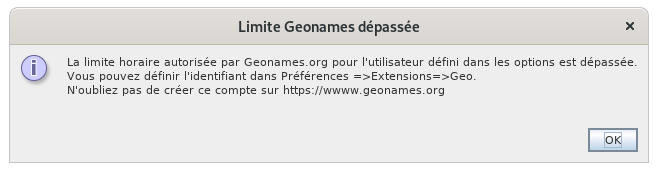
IlAll vousyou suffithave alorsto dedo is :
créercreateunacomptefreegratuitaccountsuron Geonamesactiveractivatelesgeonames web servicesgeonamesindiquerindicatel'identifiantthe identifier geonamesdansinlesthe ancestral optionsancestris
VousYou pourrezmay atteindrereach lathe limitelimit siif vousyou faitesdo unean opérationoperation avecwith beaucoupmany desplaces, lieux,but maisin engeneral, général,you vousshould neno devriezlonger plusbe subir de limite.limited.
PourTo changerchange lethe comptegeonames geonames,account, allezgo dansto lesthe préférences,preferences, voletExtensions Extensions, ongletpane, Geo :tab:

AInstead laof placeancestris, d'ancestris,you vouswill mettrezput votreyour identifiantidentifier quandwhen vousyou l'aurez.have it.
PourTo lecreate créer,it, cliquezclick suron lethe boutonbutton "CréerCreate una comptefree Geonames gratuit"account" quiwhich correspondcorresponds àto cethis lienlink https://www.geonames.org/login, etand vousyou arrivezwill surarrive laon page de création de compte dethe Geonames :account creation page:
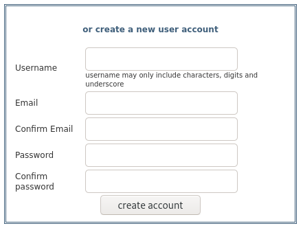
VousYou créezcreate votreyour comptepersonal personnelaccount etand una écranscreen voustells dityou qu'unthat an email voushas abeen étésent envoyé.to Allezyou. voirGo vosto mailsyour etemails cliquezand surclick leon lienthe d'account activation du compte.link.
IlThen fautyou ensuitehave activerto lesactivate webservices the geonames.geonames webservices.
PourTo cela,do connectez-vousso, àlog in to Geonames etand allezgo dansto votreyour profilprofile (lienlink enon hautthe àtop droite)right). C'estIt's ici :here: http://www.geonames.org/manageaccount. EnAt basthe vousbottom avezyou unehave zonean marquéarea marked "Free web services".

CliquezClick suron lethe lienlink etand vousyou devriezshould voirsee cetthis écran :screen:

Enfin,Finally, indiquezindicate votreyour identifiantidentifier dansin lesthe préférences,preferences, voletExtensions Extensions, ongletpane, Geo. tab.
PersonnalisationCustomization
LaThe seule personnalisationonly possible estcustomization celleis dethat l'affichageof desthe lieux.display of places.
OnYou peutmay vouloirindeed enwant effetto triersort lesthe lieuxplaces parby payscountry dansin cettethis liste,list, etand defrom lathe juridictionlargest lato plusthe grandesmallest à la plus petite.jurisdiction.
CommeAs cettethis listelist estis triéesorted alphabétiquement,alphabetically, celathis veutmeans direthat qu'ilyou fauthave afficherto lesdisplay juridctionsthe dansjurisdictions l'ordrein inversethe oùreverse elleorder sontin saisie.which they are entered.
CetThis ordredisplay d'affichageorder nedoes modifienot paschange vosyour données.data.
LaCustomization personnalisationcan s'obtientbe pardone lethrough the contextual menu contextuelof desthe lieux :places:
LaThe fenêtrefollowing suivantewindow apparaît.appears. ParFor exemple,example, parby défaut,default, lesthe lieuxplaces sontare formatésformatted dansin cetthis ordreorder etand sans effet dewithout style :effect: 0,1,2,3,4 :4:

SiIf l'onwe souhaitewant inverserto l'ordre,reverse onthe vaorder, doncwe saisirwill therefore enter 4,3,2,1,0. SiIf enwe plusalso onwant veutthe lecountry paysin enbold grasand et lethe County enin italique,italics, onwe écrirawill ceciwrite :this:
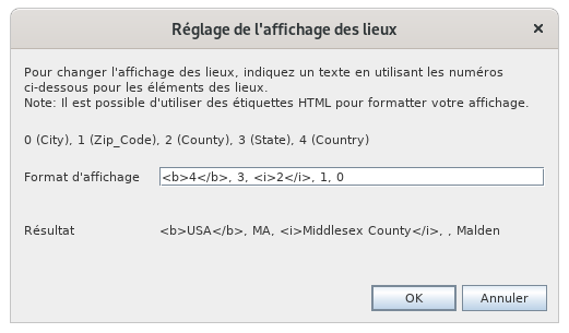
/!\By Bug :clicking on ne devrait pas voir les tag html dans la ligne résultat
En cliquant sur OK, onwe obtientget lathe listelist triéesorted parby payscountry avecwith notreour effetbold deand italic style gras et italique :effect:
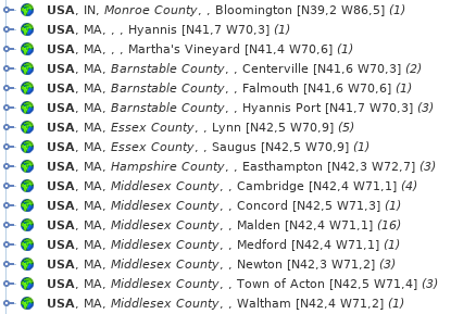
CetteThis personnalisationcustomization affectealso aussiaffects l'affichagethe desdisplay vignettesof surthumbnails laon cartethe géographique :
map:

EnIndeed, effet,the lesjurisdictions juridictionsof duthe nomcity dename laare villenot nedisplayed sontin pasthe affichéessame dansorder leas même ordre que plus haut.above.