Mapa geográfico
TheEl mapa GGeographiceográfico mapmuestra displaystodos alllos theeventos genealogygenealógicos eventsen atsu theirubicación locationen onun a map.mapa.
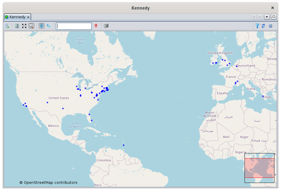
YouPuede canvisualizar visualizedónde wheretuvieron thelugar eventslos youeventos areque interestedle ininteresan. took place. InEn particular, youpuede canaplicar applyfiltros filterspara tover seesolo onlyciertos certaineventos eventsy andasí thushacer makeanálisis geographicalgeográficos analysesde ofsu your population.población.
DescriptionDescripción
TheEl MapMapa
TheEl mapmapa ises anun OpenStreetMap oversobre whichel cual Ancestris plotstraza thelos events.eventos. TheLos bluepuntos dotsazules representrepresentan placeslugares wheredonde thetuvieron eventslugar oflos youreventos genealogyde tooksu place.genealogía.
UpDe close,cerca, un marcador es un círculo con una cruz en el centro. Desde la distancia, se puede reducir a markerun is a circle with a cross in the center. From a distance, it can be reduced to a point.punto.
TwoDos visualherramientas toolsvisuales appearaparecen onen theel map:mapa:
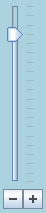
theEl control deslizante de zoomsliderenatlathepartebottominferiorleftizquierdawithconbuttonsbotones
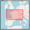
theEl minilocationmapamapdeatubicacióntheenbottomlaright.parteTheinferiorredderecha.frameElrepresentsmarcotherojo representa la parte visibleparteninrelaciónrelationcontounaárealargermásareagrandeofdelthemapamain map.principal.
ToolbarBarra de herramientas
AUna toolbarbarra atde theherramientas topen allowsla youparte tosuperior modifyle thepermite displaymodificar andla applyvisualización filters.y aplicar filtros.

DisplayBotón theMostrar listla oflista placesde Buttonlugares
ThisEste buttonbotón opensabre thela vista ListLista ofde places view.
Show/Hide zoom Button
This button shows or hides the zoom sliderlugares.
ShowBotón allMostrar/Ocultar markers Buttonzoom
ThisEste buttonbotón adjustsmuestra theu oculta el control deslizante del zoom.
Botón Mostrar todos los marcadores
Este botón ajusta el nivel de zoom levely andcentra centersel themapa mappara soque thatpueda youver cantodos seelos allmarcadores the genealogy markers.genealógicos.
Show/HideBotón overviewMostrar/Ocultar Buttonvisión general
ThisEste buttonbotón showsmuestra oru hidesoculta thela mini card.tarjeta.
Show/HideBotón markersMostrar/Ocultar Buttonmarcadores
ThisEste buttonbotón showsmuestra oru hidesoculta thelos markers.marcadores.
ToggleBotón markersAlternar Buttonmarcadores
ThisEste buttonbotón togglesalterna betweenentre twodos markermodos displayde modes.visualización de marcadores.
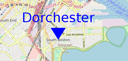
MarkerMarcador inen theforma formde ofcírculo acon circlela with the cross :cruz:
MarkerMarcador inen theforma formde ofetiqueta acon labelel withnombre thede cityla name :ciudad:
PlaceColocar filtercampo fieldde filtro
ThisEste inputcampo fieldde isentrada es un filtro de ubicación rápida. Le permite mostrar solo aquellos marcadores cuya ubicación incluye la cadena introducida.
Para usarlo, escriba caracteres y, a quickcontinuación, locationpresione filter.la Ittecla allowsIntro youpara toaplicar displayel only those markers whose location includes the entered string.filtro.
ToBorre uselos it,caracteres typey characterspulse andIntro thende pressnuevo thepara Entereliminar keyeste tofiltro.
Botón theMostrar/Ocultar filter.lugares no geolocalizados
ClearUn thelugar charactersno andgeolocalizado presses Enterun againlugar tosin removecoordenadas thisgeográficas filter.
Show/Hide non-geolocated places Button
ASe non-geolocatedcoloca placepor isdefecto frente a placela withcosta node knownBurdeos geographicen coordinates.
ItOcéano is placed by default off the coast of Bordeaux in the Atlantic Ocean.Atlántico.
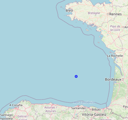
InPara orderalertar toal alertusuario thede userque thatlos placeslugares cannotno bese located,pueden andlocalizar, rathery thanen placinglugar themde oncolocarlos land,en whichtierra, wouldlo notque distinguishno themlos fromdistinguiría well-locatedde places,los welugares chosebien toubicados, place¡elegimos themcolocarlos inen theel sea!mar!
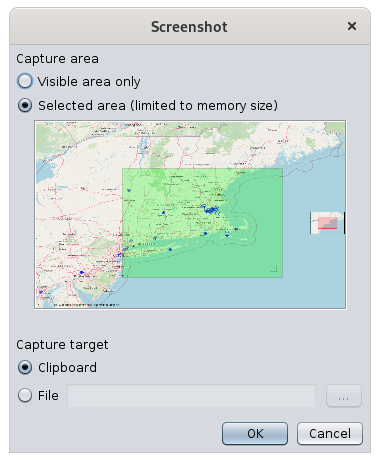
ScreenshotBotón Buttonde Captura de Pantalla
AAparece screenshotuna windowventana appearsde allowingcaptura youde topantalla chooseque ale greenpermite areaelegir toun capture,área andverde topara keepcapturar they imagemantener inla theimagen clipboarden orel inportapapeles ao file.en un archivo.
FilterIndicador indicatorde filtro 

ThisEste symbolsímbolo tellsindica yousi whetherse aestá filteraplicando isun beingfiltro appliedo or not.no.
ASe filteraplica isun beingfiltro appliedcuando whenno atse leastmuestra oneal markermenos isun not displayed.marcador.
HoveringAl overpasar thisel symbolcursor bringssobre upeste asímbolo, tooltipaparece indicatinguna whichinformación filtersobre isherramientas inque effect.indica que filtro está en vigor.
ForPor example,ejemplo, hereaquí aun filterfiltro isestá inen effectefecto topara showmostrar onlysólo thelos markersmarcadores forde los eventos de los antepasados de Joseph Kennedy's ancestors' events.Kennedy.

RefreshActualizar placeslugares fromdesde theel Botón Internet Button
ThisEste buttonbotón triggersactiva thela searchbúsqueda forde placeslugares on theen Internet. SeeConsulte thela sectionsección SearchingBúsqueda forde coordinatescoordenadas ofde alltodas locationslas ubicaciones forpara details.obtener más información.
ConfigureBotón viewConfigurar Buttonvista
a continuación.
TheEl Geographicmapa mapgeográfico isse usedutiliza to:para:
Navegar en el mapa
El mapa es móvil y ampliable, y se puede mover arrastrando el ratón con su botón pulsado en cualquier punto del mapa.
Para volver a particularcentrar geographicel areamapa, ofhaga yourdoble genealogyclic en la ubicación que se colocará en el centro de la ventana.
Se puede aplicar el nivel de zoom
- con la rueda del ratón, si queda por encima del mapa.
Identifymoviendoeventselincursor deslizante con el ratón,- paso a
givenpaso,locationhaciendo Updateclicgenealogyenlocationslos Filter particular events to analyze possible geographic relationships between individuals
Navigate on the map
The map is moveable and zoomable, and can be moved by dragging the mouse with the mouse button pressed at any point on the map.
To recenter the map, double-click on the location to be placed in the center of the window.
The zoom level can be applied
with the wheel of the mouse, if it remains above the map.by moving the slider cursor with the mouse,step by step by clicking on thebotones
buttonsjuntonextaltocontrolthe slider,deslizante,orobyhaciendoclickingcliconentheelslidercontrolanddeslizanteusingytheusandouplasandteclasdowndel cursorkeys.arriba y abajo.

ImpactImpacto ofdel thecambio de zoom changeen onel thecentro centerdel of the map :mapa:
WhenAlzoominghacerwithzoomtheconscrolllawheel,ruedathedegeographicdesplazamiento,pointelunderpuntothegeográficomousedebajoremainsdelfixed.ratón permanece fijo.WhenAlzoominghacerwithzoomtheconbuttons,losthebotones,centerelofcentrothedelmapmaparemainspermanecefixed.fijo.
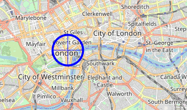
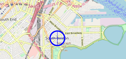
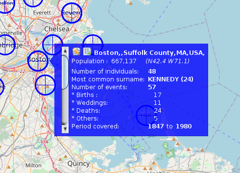
IdentifyIdentificar eventseventos inen auna givenubicación locationdeterminada
FromDesde aun placelugar markedmarcado bypor aun markermarcador onen theel map,mapa, ites isposible possibleidentificar tolos identifyeventos theque eventstuvieron thatlugar took place there.allí.
ToPara dohacer this,esto, simplysimplemente hoverpase overel thecursor markersobre withel themarcador con el mouse. AUna smallpequeña blueventana windowazul appearsaparece likecomo this one:esta:
IfSi severalhay locationsvarias areubicaciones verymuy close,cerca, thisesta windowventana containscontiene una barra de desplazamiento vertical a verticalla scrollizquierda. barAl onactivar theesta left.barra Byde activatingdesplazamiento, thispuede scrolldesplazarse barpor youcada canuna scrollde throughlas eachubicaciones ofdel the locations in the area.área.
ThisEsta windowventana displaysmuestra twodos buttonsbotones aten thela topparte followedsuperior byseguidos thedel fullnombre namecompleto ofdel thelugar placey andla theinformación informationsobre aboutel the place :lugar:
The window then displays the events that occurred there, a bit like a flash report :
- The number of individuals in relation to this place in your genealogy
- The most frequent lastnames in this place, and the number of times it is mentioned.
- The number of events that took place there, detailed below by type of event: births, marriages, deaths and others.
- The period in years covered by these events.
Update places
It is possible to update places in two complementary ways:
- By right-clicking on a point on the map, to identify surrounding locations or to capture the exact coordinates of a location using a location pop-up menu.
- By editing the place, using the place editor that opens from the blue window button described above.
Place pop-up menu
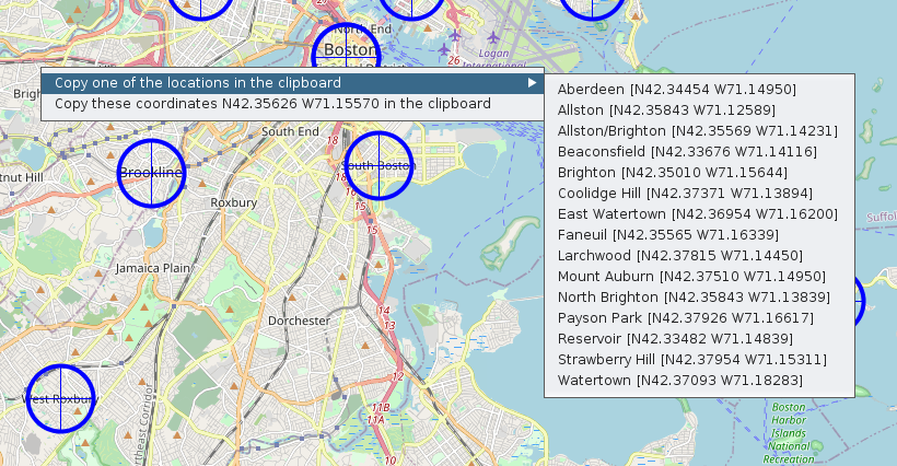
Two actions appear:
- Copy one of the locations to the clipboard: you can retrieve one of the places from the list in order to use it later.
- Copy the coordinates XXXXX YYYYY to the clipboard: this retrieves the exact coordinates of the place to use it later.
Place Editor
From the Edit this place button in the blue window above, you can edit a place.
See the Place Editor for more details.
Event Filters
One of the main interests of the map is to be able to apply filters to identify and analyze possible geographical relationships between individuals.
To apply filters, go to Configure View Settings. This window appears:
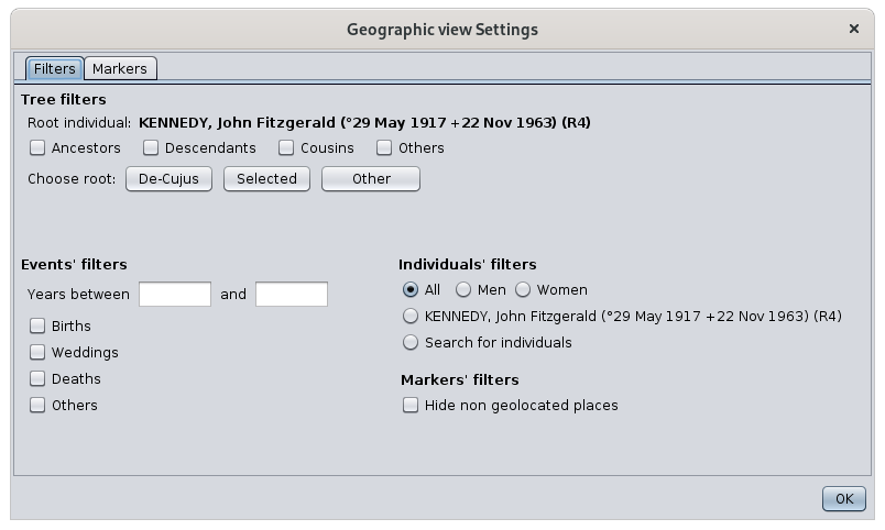
There are 4 groups of filters :
- Filters on the relationship of ascendancy or descent in a reference to a root individual which is defined only for this occasion.
- The checkboxes allow you to apply the filters. The corresponding groups of individuals will be included in the displayed markers
- Three buttons allow you to change the root individual directly if the current one doesn't suit you
- Its name is displayed above the check marks
- No numbering or data changes result from this choice of root individual
- Filters by type of event and by date of the event.
- This will display all events that correspond to the checkboxes and that fit within the period entered if any.
- Filters on individuals.
- Gender: only displays the event locations of individuals of the specified gender.
- Name of selected individual: displays only the places of the events of the selected individual whose name is displayed
- Search for individuals: displays only places with events of individuals from the advanced search
- Filter on the spot.
- Simple filter on non-geolocated locations
Any action on a filter in this window immediately updates the map.
Filters from different groups are combined with each other so that the displayed markers will have to match all conditions.
The use of filters is particularly interesting. It allows for example to answer the question: where are all the people of my genealogy whose occupation is a baker ?
To do this, simply search for all individuals with a baker occupation in the Advanced search window. Leaving this window open, go to the geographic filters above and check the "Search for individuals" box. The map will then display only the places that have had an event from a baker. You can also check the "Birth" box to have only the places of birth of the bakers.
Customization
It is possible to change the appearance of the markers :
- Their size
- Automatic adjustment of their size with the zoom level
- Their color
To do this, from the Configure View Settings, go to the Markers tab and make your choice of size and color.
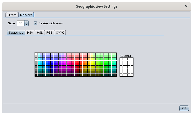
By default, the size of the markers adjusts to the zoom level used.
- The closer the map is, the larger the markers are, as they are more easily visible and do not overlap each other.
- The further away the map is, the more markers there are and the more you need to reduce them in size. On the other hand, since the map gives less detail of the topology of the places, they are also more visible and therefore do not need to be as large.
If you do not want Ancestris to change the size of the markers, uncheck the "Resize to fit zoom" box.